


JMM La Chapelle Gauthier - Forêt de Villefermoy - 11 km

jeanmarcMasson
User GUIDE
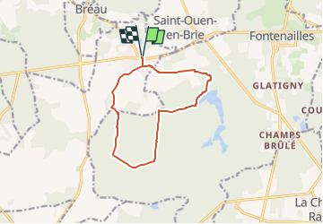

Length
10.8 km

Max alt
132 m

Uphill gradient
109 m
Km-Effort
12.2 km

Min alt
94 m

Downhill gradient
108 m
Boucle
Yes
Creation date :
2025-04-19 09:59:09.857
Updated on :
2025-04-22 06:50:02.381
2h46
Difficulty : Difficult

FREE GPS app for hiking
 SityTrail
IGN / Geographical institutes
SityTrail Plus
The world is yours!
About
Trail Walking of 10.8 km to be discovered at Ile-de-France, Seine-et-Marne, La Chapelle-Gauthier. This trail is proposed by jeanmarcMasson.
Positioning
Country:
France
Region :
Ile-de-France
Department/Province :
Seine-et-Marne
Municipality :
La Chapelle-Gauthier
Location:
Unknown
Start:(Dec)
Start:(UTM)
492659 ; 5377437 (31U) N.
Comments